Digital Agriculture
Time Series Mastery: How to Use Field History to Enhance Future Agronomy
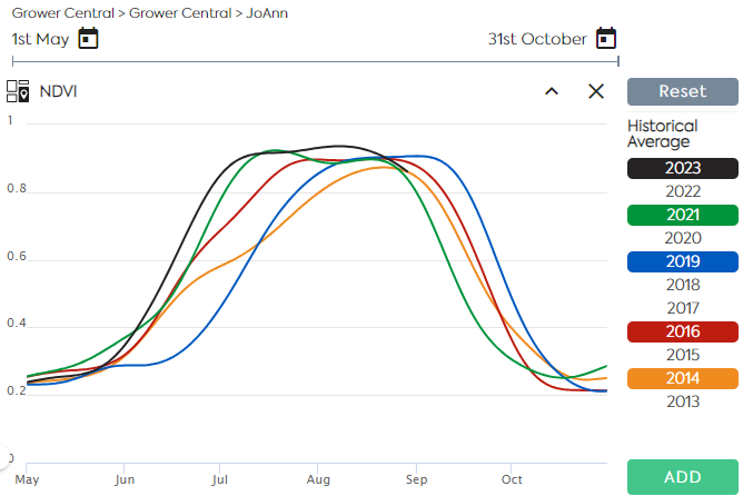
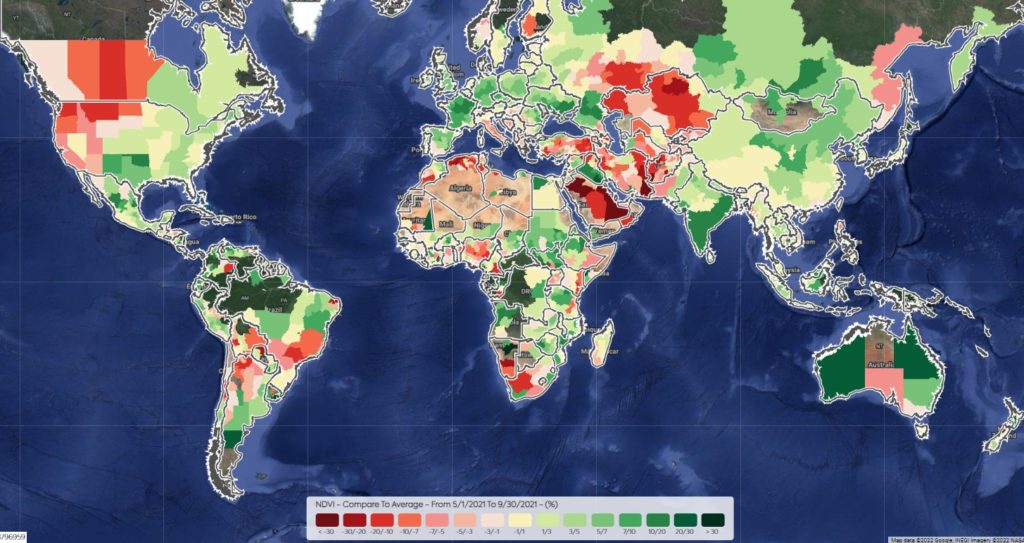
Satellite Imagery allows users to monitor near–real–time crop growth conditions along the vegetation cycle. A Satellite Image Time Series is a sequence of images taken over the same area at various intervals. Time series of indices derived from reflectance data, such as NDVI and LAI are used to assess the evolution of the vegetation and…
Read MoreEarthDaily Agro and Infopulse Help a Large Ukrainian Agro-holding Access Precision Agriculture
Aiming to enable data-driven decisions and ensure more efficient use of its resources, one of the leading industrial agro-holdings in Ukraine decided to adopt the precision agriculture approach. The company’s primary objective was to engineer a modern cloud-based data platform that would gather, consolidate, and analyze vast volumes of agricultural data, including high-resolution satellite images…
Read MoreEmployee Spotlight – Yuriy Pekun

While working at the Ministry of Finance of Ukraine, Yuriy Pekun discovered a deep passion for agriculture. This led him to pursue and obtain a master’s degree in agronomy and crop science, which was a turning point in his career. Before joining the EarthDaily Agro team, he served as an agronomist for seed growing companies.…
Read MoreIf You’re Looking for Agribusiness Solutions, Look to the Sky
There are more than 8,000 satellites orbiting the Earth today — and almost as many different jobs they’re doing up there. Satellites have been helping humans solve problems for years. From capturing solar power to enabling global communications to viewing the deep reaches of space, satellites have been behind some of the biggest technological advancements…
Read MoreSatellite – Scaling Up Carbon Farming
In recent years, many studies on carbon farming practices have been done. Optimizing carbon capture on working landscapes is expanding in the United States and in other major production areas around the world. In coordination with these efforts, a framework is being structured that encompasses political and financial incentives, regulatory frameworks, contracted production, and debate…
Read MoreEarthDaily Analytics Announces New Global Food Security Initiative in Response to Crisis in Ukraine
EarthDaily Analytics stands with all who are impacted by the crisis in Ukraine. Our first course of action was terminating our business operations in Russia, making clear that we stand firmly in opposition to the invasion of Ukraine. Now, we are further putting our principles into action by expanding our support to a global community…
Read MoreQ&A: Integration with John Deere Operations Center

Last July, we proudly announced our integration with the John Deere Operations Center. By making maps from our Croptical tool available through the Operations Center, dealers across the globe have access to industry-leading satellite imagery to enable better decision making throughout the growing season. Plus, Croptical gives you access to advanced data analytics for comprehensive…
Read MoreReducing Financial Risk for a Global Insurance Leader
The <geosys/> dataset provides the insurer with the information needed to analyze weather and climate conditions and make informed decisions for writing policies and responding to claims. Millions of hectares across Brazil—approximately a third of the country’s land area—are devoted to agriculture. In particular, corn and soybean production has increased significantly in recent years because…
Read MoreRemote sensing for oilseed rape fertilisation – How EarthDaily Agro supports nitrogen management.
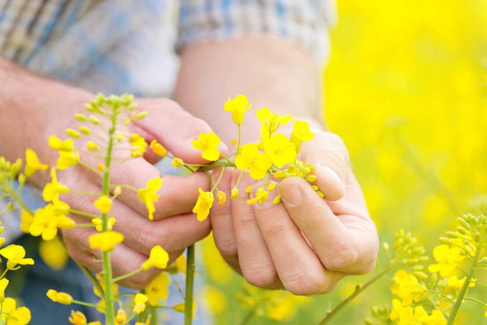
Satellite imagery technology is a component of precision agriculture that accompanies agricultural practices. During this winter period in Western Europe, satellite images are being used on winter oilseed rape fields to adapt nitrogen fertilisation and better distribute it into the field, thanks to variability maps. Biomass is an indicator of the amount of nitrogen absorbed…
Read MoreRevolutionizing the Agricultural Financial Market
Using Data and Technology to Mitigate Uncertainties, Increase Operational Efficiency, and Reduce Costs Founded by MIT alumni, the ag-fintech company Traive is embracing technology to disrupt the financial industry. In fact, their current mission is to revolutionize the agricultural finance sector through data technology and machine learning. Based in Brazil and the U.S., the…
Read More