
New Features Bring Even More Power to Geosys Platform
In January 2021, EarthDaily Agro announced its next generation Platform as a Service (Paas), <geosys/>. Today we are announcing our first major release of updates that improve the performance, scope and usability of our PaaS offering. With a full suite of enhancements, the updated platform makes harnessing satellite imagery for agriculture easy and offers advanced geospatial analytics even more impactful for the organizations and people who feed the planet.
The platform simplifies decision-making.
Key updates in the new release include:
- Empower developer communities: With robust content on GitHub, developers can collaborate around the world. New content includes:
- QGIS functionality: Through a new plugin, discover, request and use aggregate imagery products based on our virtual constellation including Landsat 8, Landsat 9, Sentinel 2 and other sensors from within QGIS, leveraging the <geosys/> API.
- GeosysPy package: Enable your data science team to include satellite derived metrics within your artificial intelligence/machine learning modeling efforts.
- Data: The <geosys/> platform makes static data sets available for use.
- 10+ years of historical and cloud mask datasets for yield modeling training, carbon modeling/testing, precision agriculture, land use classification and crop identification models training.
- With our scientific-grade satellite data and A.I. capabilities, the <geosys/> team has successfully identified and mapped out 300,000+ irrigation pivots across the U.S., Brazil and Canada.
- Analytic stream formatter: Create and customize analytic pipelines within your own platform.
- Seamless experience: However customers access the platform, a unified user experience makes leveraging a wide range of analytics simple.
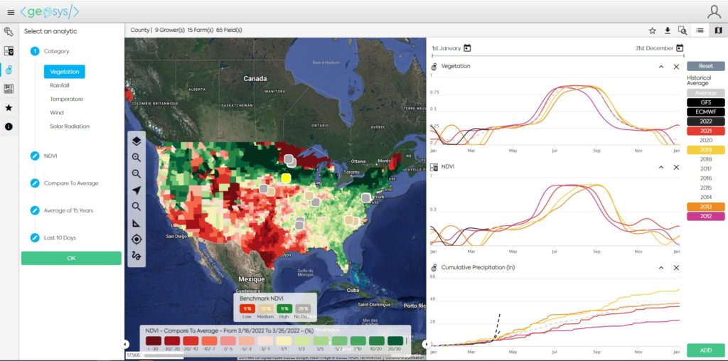
- Regionwide monitoring: Field-level and region-level data can now be easily viewed together.
- Visual enhancements: Map displays, time-lapse views and data visualization have all received improvements.
- Field manager improvements: Crop rotation information as well as subscription services have now been integrated into the <geosys/> app.
- Dashboard integration: Custom Tableau dashboards can now be accessed directly within the <geosys/> app.
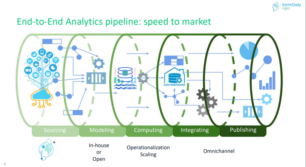
The platform supports users through the entire analytics lifecycle.
Using a Platform as a Service model, the <geosys/> platform makes geospatial analytics:
- Flexible: Multiscale customization options support omnichannel delivery using role-based security model.
- Integrated: connectors and plugins with major communities make integration seamless.
- Extensible: Module-based widgets facilitate new analytic integration with low code approach.
- Easy: A simple and efficient interface, documentation and more streamline user experience.
- Scalable: A global platform, <geosys/> adapts to customers’ business workflows, enables multiscale analysis levels and automation, and offers global coverage.
Contact EarthDaily Agro to learn how geospatial insights can move your business forward.