Posts Tagged ‘About’
Time Series Mastery: How to Use Field History to Enhance Future Agronomy
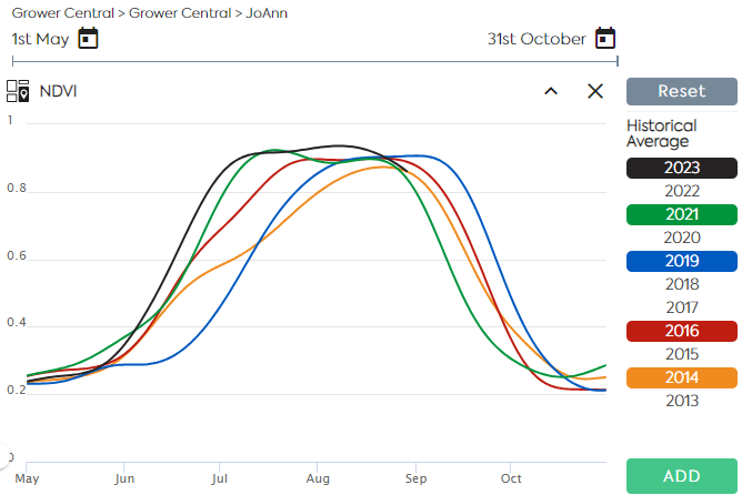
Satellite Imagery allows users to monitor near–real–time crop growth conditions along the vegetation cycle. A Satellite Image Time Series is a sequence of images taken over the same area at various intervals. Time series of indices derived from reflectance data, such as NDVI and LAI are used to assess the evolution of the vegetation and…
Read MoreEmployee Spotlight: Caroline Gevaert

How long have you been at EarthDaily Agro? I joined EarthDaily Agro 12 years ago. What’s your current position, and what does it entail? My current role as a Data Analyst involves transforming raw data into useful insights. I am responsible for collecting, processing, and analyzing data to provide valuable materials to data scientists.…
Read MoreEmployee Spotlight: Alexis Durand

How long have you been at EarthDaily Agro? Three years. What’s your current position, and what does it entail? I am a data scientist and as such I am responsible for creating analytics based on machine learning and deep learning. Specifically, I work on detecting objects in satellite images, such as irrigation systems (pivots). I…
Read MoreEmployee Spotlight – Yuriy Pekun

While working at the Ministry of Finance of Ukraine, Yuriy Pekun discovered a deep passion for agriculture. This led him to pursue and obtain a master’s degree in agronomy and crop science, which was a turning point in his career. Before joining the EarthDaily Agro team, he served as an agronomist for seed growing companies.…
Read MoreAntarctica Capital Announces Formation of EarthDaily Analytics
NEW YORK, April 21, 2021 – Antarctica Capital, an international private equity firm, today announced the formation of EarthDaily Analytics (“EarthDaily”), an integrated data processing and analytics company offering advanced digital products and analytics for delivery to the world’s rapidly expanding global agricultural industry. EarthDaily Analytics utilizes satellites to collect vast amounts of raw imagery…
Read MoreCrop insurers adopt satellite remote sensing technology to monitor crop progress
Technology offered by EarthDaily Agro brings speed and precision in monitoring insured properties, amid the Covid-19 pandemic Crop producers in all regions of Brazil purchased more than 193,000 crop insurance policies last year covering 13.7 million hectares. This represents about 21% of Brazil’s total farming area according to the Ministry of Agriculture, Livestock and Supply…
Read MoreEarthDaily Agro Appoints Veteran Sales and Marketing Executives to Support Global Growth

EarthDaily Agro announced the appointment of David E Gray as Global Director of Sales & Business Development and J. Andrew Mullin as Global Director of Marketing. Gray and Mullin join the leadership team of EarthDaily Agro to scale the worldwide sales and marketing organization, supporting the company’s rapid growth. Gray is a recognized leader of…
Read MoreEarthDaily Agro Emerges as a Dominant Player for Geospatial Analytics in Global Agriculture

MINNEAPOLIS, Nov. 9, 2021 /PRNewswire/ — Satellite imagery and data is helping agriculture companies grow to new heights. EarthDaily Agro, the agricultural division of EarthDaily Analytics, has reported significant growth in 2021 as demand for geoanalytic data rises. “EarthDaily Agro has achieved significant growth thus far in 2021 fueled by its focus on fintech and Brazil” said Don Osborne, Chief Executive Officer of…
Read MoreEmployee Spotlight: Rachel Leonard

How long have you been at EarthDaily Agro? 10 years! What’s your current position, and what does it entail? I am a business analyst, and my role is primarily to interface between sales, key accounts, development, data science, and operations teams to follow the project’s lifecycle from inception to delivery! I create a lot of…
Read MoreEarthDaily Agro strengthens offering in Brazil with addition of CBERS-4 to virtual constellation by utilizing EarthPipeline technology
We are pleased to announce the addition of CBERS-4 to the EarthDaily Agro virtual constellation for our customers in Brazil. CBERS-4 is a broad area coverage mission well suited for agriculture due to its Multispectral Camera (MUXCam) which was jointly developed by the governments of China and Brazil. This latest addition to the EarthDaily Agro…
Read More