Weather Analytics Help Brazilian Insurer Reduce Daily Risk in Agriculture
Geospatial analytics helps Brazilian insurer take proactive steps to reduce the cost of claims with timely weather monitoring, forecasts and alerts.
Protecting farmers from the risks of flood, drought, frost and other weather- and climate-related conditions can create financial risk for insurers—for example, when farmers in Brazil submit increased claims due to crop failure caused by extreme weather. To stay ahead of claims processing across Brazil’s 150 million acres of cropland, insurers must forecast in advance the current conditions, forecasts and historical data that could lead to a weather event.
For over a decade, a leading insurer in Brazil has benefited from geospatial analytics from EarthDaily Agro. With Earth Observation data—remote sensing of the Earth’s surface to analyze ground-level conditions—insurers can work more efficiently and profitably even during periods of increased claims.
EarthDaily Agro’s powerful geosys Platform combines satellite imagery with geospatial analytics to help insurers make informed decisions based on weather-related conditions. The platform can deliver this information via a ready-to-use app or through an API for easy integration into proprietary data blocks. What’s more, EarthDaily Agro’s expert agronomists regularly consult with customers to help analyze data and determine the best course of action.
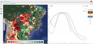
When it comes to risk management, the geosys Platform supports insurers through a variety of capabilities. Maps and analytics drill down to the field level to determine daily weather conditions that could affect crops. The app creates risk maps for underwriting using 20 years of historical weather conditions.
“As a user of EarthDaily Agro, we gain a better understanding from Earth Observation data of how weather and climate impact our own customers, which helps us make more informed decisions for mitigating risk.”
With this information, insurers can define accurate premiums and coverage by combining risk maps with field-level vegetation data to better understand individual performance—helping insurers create competitive market pricing by establishing unique portfolios based on risk profiles. For claims processing, insurers can easily view climate conditions during specific time periods to determine if a given claim is viable.
As a result of the geosys Platform data, insurers can easily analyze field conditions—speeding up claims processing, mitigating risk and helping insurers stay profitable.
On the horizon: Daily observation from EarthDaily Analytics
Coming soon, EarthDaily Analytics, the parent company of EarthDaily Agro, will launch the EarthDaily satellite constellation, the world’s most powerful global change detection and analysis system. Through a unique combination of 23 spectral bands, the satellites will collect scientific-grade and analytics-ready imagery of the Earth’s surface captured every day, at the same time of day and made available within hours through a cloud-based platform.