Archive for March 2024
Time Series Mastery: How to Use Field History to Enhance Future Agronomy
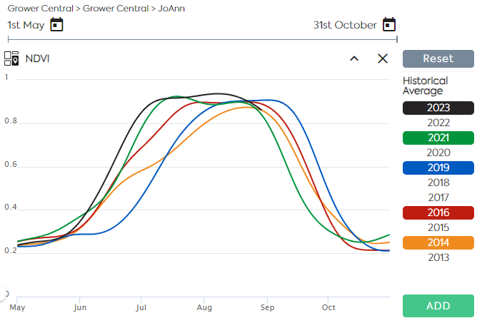
Satellite Imagery allows users to monitor near–real–time crop growth conditions along the vegetation cycle. A Satellite Image Time Series is a sequence of images taken over the same area at various intervals. Time series of indices derived from reflectance data, such as NDVI and LAI are used to assess the evolution of the vegetation and…
Read MoreValue Chain Collaboration Enables new Solution among the lowest carbon intensity renewable fuels in the marketplace.
The world’s agri-food leaders are aligned — this is an industry with immense potential to drive positive influence on worldwide climate resilience. For many organizations, the first steps — prioritizing the importance of climate resilience and deciding what commitments to pursue — are complete or in-progress. This is a milestone to celebrate. The momentum that…
Read MoreUnlocking the Potential of Remote Sensing: Estimating Winter Cover Crop Biomass Using Sentinel-2 and Machine Learning
In the pursuit of sustainable agriculture and climate change mitigation, understanding and quantifying the biomass of cover crops during winter fallow periods is crucial. However, traditional methods for estimating cover crop biomass often lack spatial precision and objectivity. In a groundbreaking study published in Remote Sensing, researchers have harnessed the power of remote sensing technology…
Read More