
Reducing Insurance Risk With Proactive Action Powered by Earth Observation
A leading French agricultural insurer harnesses powerful weather and climate data from EarthDaily Agro to better predict risk and establish policy, enabling the company to respond proactively and ultimately support its bottom line.
Insurance by nature can be a reactive business, which often creates challenges for insurers as it exposes them to risk. A leading French agricultural insurer, though, has been able to reduce risk through proactive insights from Earth Observation. By harnessing powerful weather and climate data from EarthDaily Agro, the insurer is able to better predict risk and establish policy, enabling the company to respond proactively and ultimately support its bottom line.
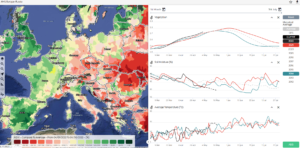
EarthDaily Agro’s satellite-based analytics platform helps forecast for upcoming crop and climate conditions, whether by field, by region or across France. The combination of powerful app, robust data stream and expert analytical services provides the insurer the information needed to inform risk models and flag areas within the insurance portfolio that could have potential problems based on weather or climate.
“As we evaluate our models based on underlying risk, we use Earth Observation and geospatial analytics as one of the inputs into how we evaluate pricing.”
The cloud-based platform includes vegetation indexes, such as NDVI, as well as agronomic analytics, weather data, and notifications and warnings. But more than set of data and analytics, EarthDaily Agro specializes in expert analytical services. EarthDaily Agro’s professional agronomists meet with the insurer as often as weekly, providing both local expertise and subject matter expertise to help interpret patterns and identify opportunities.
The platform monitors crop and climate events, including NDVI, at the regional level. This high-quality, regional-level data by crop makes it easy for insurers to predict problem areas in their portfolios based on unfavorable crop conditions that result in lower yield or potentially a loss. When a claim occurs, historical weather data from can verify conditions at the time the claim was filed. This is an efficient way to verify conditions across a region without sending a claim adjuster into the field.
The platform’s simplicity and ease of use allows the insurer to take action in a timely manner. What’s more, thanks to EarthDaily Agro’s breadth of coverage, the insurer can use the platform across all the regions it serves, ensuring data is always consistent and seamless. Finally, because of the depth of expertise of the EarthDaily Agro team, the strong relationship provides the insurer a trusted partner to help them navigate responsively to new business challenges — for example, regulatory changes that require process updates.
On the horizon: Daily observation from EarthDaily Analytics
Coming soon, EarthDaily Analytics will launch the EarthDaily satellite constellation, the world’s most powerful global change detection and analysis system. In a unique combination of 23 spectral bands, the satellites will collect scientific-grade and analytics-ready imagery of the Earth’s land mass captured every day, at the same time of day and made available within hours through a cloud-based platform.