South America
Reducing risk for agribusinesses with Earth Observation and AI-powered analytics
Our customers and partners include leaders and innovators across the public and private sectors, including long-established and instantly familiar names, up-and-coming firms at the cutting edge of their fields, and numerous companies that have realized the tangible value of having a better, more contextualized, and more up-to-date understanding of the world around them. As we…
Read MoreReduzindo o risco para o agronegócio com dados de observação da Terra e análise baseada em IA
Nossos clientes e parceiros incluem líderes e inovadores nos setores público e privado, incluindo nomes estabelecidos há muito tempo e familiares no mercado, como empresas promissoras na vanguarda de seus segmentos e inúmeras empresas que perceberam o valor tangível de ter uma compreensão melhor, mais contextualizada e mais atualizada do mundo ao seu redor. Enquanto…
Read More5 Takeaways on 2022 Global Crop Production Powered by Earth Observation
Every year comes with its own crop production challenges, but few years in recent memory compare with the disruptions of 2022. From the war in Ukraine to extreme weather patterns to rising population and more, a host of challenges tested the resilience of the entire agricultural supply chain. All year long, expert agronomists at EarthDaily…
Read MoreIf You’re Looking for Agribusiness Solutions, Look to the Sky
There are more than 8,000 satellites orbiting the Earth today — and almost as many different jobs they’re doing up there. Satellites have been helping humans solve problems for years. From capturing solar power to enabling global communications to viewing the deep reaches of space, satellites have been behind some of the biggest technological advancements…
Read MoreSatellite – Scaling Up Carbon Farming
In recent years, many studies on carbon farming practices have been done. Optimizing carbon capture on working landscapes is expanding in the United States and in other major production areas around the world. In coordination with these efforts, a framework is being structured that encompasses political and financial incentives, regulatory frameworks, contracted production, and debate…
Read MoreCrop insurers adopt satellite remote sensing technology to monitor crop progress
Technology offered by EarthDaily Agro brings speed and precision in monitoring insured properties, amid the Covid-19 pandemic Crop producers in all regions of Brazil purchased more than 193,000 crop insurance policies last year covering 13.7 million hectares. This represents about 21% of Brazil’s total farming area according to the Ministry of Agriculture, Livestock and Supply…
Read MoreEarthDaily Agro strengthens offering in Brazil with addition of CBERS-4 to virtual constellation by utilizing EarthPipeline technology
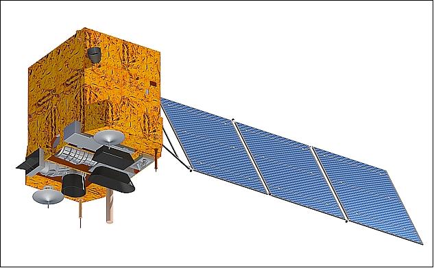
We are pleased to announce the addition of CBERS-4 to the EarthDaily Agro virtual constellation for our customers in Brazil. CBERS-4 is a broad area coverage mission well suited for agriculture due to its Multispectral Camera (MUXCam) which was jointly developed by the governments of China and Brazil. This latest addition to the EarthDaily Agro…
Read MoreReducing Financial Risk for a Global Insurance Leader
The <geosys/> dataset provides the insurer with the information needed to analyze weather and climate conditions and make informed decisions for writing policies and responding to claims. Millions of hectares across Brazil—approximately a third of the country’s land area—are devoted to agriculture. In particular, corn and soybean production has increased significantly in recent years because…
Read MoreRevolutionizing the Agricultural Financial Market
Using Data and Technology to Mitigate Uncertainties, Increase Operational Efficiency, and Reduce Costs Founded by MIT alumni, the ag-fintech company Traive is embracing technology to disrupt the financial industry. In fact, their current mission is to revolutionize the agricultural finance sector through data technology and machine learning. Based in Brazil and the U.S., the…
Read MoreSatellite remote sensing reduces risk for agriculture credit lending
Geospatial data tools allow the crop history of each field to be analysed for better decision-making or lenders and growers Farming credit has been a fundamental tool for the development of Brazilian agriculture for decades, growing significantly to meet the demand of the Brazilian agricultural sector. Between 1995 and 2018, the amount of credit officially…
Read More